


Pont d'Argens - Canal St Croix

soca
User
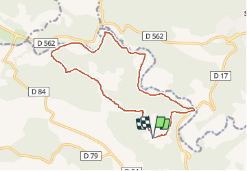

Length
9 km

Max alt
187 m

Uphill gradient
176 m
Km-Effort
11.3 km

Min alt
96 m

Downhill gradient
173 m
Boucle
Yes
Creation date :
2021-03-23 07:21:58.451
Updated on :
2021-03-23 07:23:13.496
3h40
Difficulty : Easy

FREE GPS app for hiking
 SityTrail
IGN / Geographical institutes
SityTrail Plus
The world is yours!
About
Trail Walking of 9 km to be discovered at Provence-Alpes-Côte d'Azur, Var, Le Thoronet. This trail is proposed by soca.
Positioning
Country:
France
Region :
Provence-Alpes-Côte d'Azur
Department/Province :
Var
Municipality :
Le Thoronet
Location:
Unknown
Start:(Dec)
Start:(UTM)
281692 ; 4815593 (32T) N.
Comments